Community listing page, reviews here may not be monitored by the author.

Community voices
Reviews
No reviews yet. Be the first to review this project!
Get it on
Available Platforms
About
Project Details
For authors
Embed Badge
If you're the author of this project, you can embed a live badge anywhere that supports HTML or Markdown. It updates automatically whenever ratings change.
Use HTML for any page that supports it, or Markdown for README files and Markdown-based descriptions.
Identifiers
Platform IDs
Resources
External Links
About
Description
🧭 GPS Navigation Mod (Client-Side)



GPS is a 100% Client-Side satellite map and smart road navigation mod for Minecraft 1.12.2.
It guides you through your built roads, offers an ultra-smooth minimap with cave support, and lets you share explored maps with friends!
1.0.3 Update is coming!
🌟 Features
🚗 Smart Road GPS & 3D Navigation
- Advanced Pathfinding: Calculates the fastest, most optimal route strictly along your road network.
- Lane Centering: Dynamically centers the navigation line in the median of any road width (from 3 to 24+ blocks wide).
- Directional Flow Control: Fully supports One-Way and Two-Way streets with intelligent routing logic calculated directly from your current position!
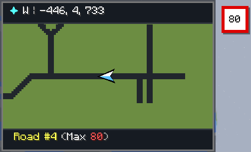
- Speed Limits & Street Names: Dynamically displays real-time street names and authentic speed limit signs on your HUD as you drive or walk.
- Road Visibility Toggle: Choose whether individual road segments are colored and visible or completely hidden from the map and radar while keeping smart GPS navigation 100% active over them!
- No Corner Cutting: Stays 100% inside road intersections without clipping grass or curbs.
- Visual 3D Guidance: Guides you with a smooth, glowing line in the 3D world and on your mini-radar HUD.
🌉 Multi-Layer Bridges & Tunnels System (NEW!)
- 3D Height-Aware Routing: Define any road segment as SURFACE, BRIDGE, or TUNNEL. Overpasses and underpasses never collide or merge erroneously!
- Layer-Ordered Rendering: Tunnels render subterranean with dimmed lighting, surface roads render normally, and elevated bridges render on top with realistic, semi-transparent drop shadows.
- Smart Vertical Snapping: The GPS pathfinder intelligently calculates vertical road clearance so high bridges passing over low roads never cause accidental shortcuts.
🖨️ High-Resolution Map PNG Exporter (NEW!)
- One-Click Ultra-HD Export: Export your entire explored world as a lossless, high-resolution PNG image directly from the map sidebar.
- Saved Location: Exported map images are automatically saved to: 📁 .minecraft/gps_maps/exports/
- Vector Overlay Stitches: Automatically stitches all explored regions with drawn road networks, waypoint badges, and a crisp HUD distance scale legend.
- Instant In-Game Link: Click directly on the chat message to immediately open the exported map in your default photo viewer or folder!
✨ Cyber Glassmorphism & Animation Engine (NEW!)
- Frame-Independent Physics Engine: Ultra-smooth easing animations computed via real-time delta timing — buttery smooth on 60Hz, 120Hz, 144Hz, and 240Hz+ displays!
- Tactile Interactive Buttons: Features continuous hover interpolation, vibrant expanding accent stripes, outer neon glow auras, subtle text/icon nudges, and physical 1px tactile click depression.
- Frosted Glass Pop-In Modals: Dialogs smoothly scale in with an elastic spring bounce, layered soft drop shadows, and high-tech corner brackets across all menus.
- Dynamic Fullscreen Map Sidebar: Opens with a smooth slide-in deceleration animation, glowing search box halo, and an animated live RTK GPS satellite lock beacon.
🌈 Dynamic RGB & Chroma Rainbow System (IMPROVED!)
- Compact Responsive Layout: Redesigned to fit 100% cleanly on any screen resolution and any Minecraft GUI Scale (Small, Normal, Large, Auto) without clipping off-screen.
- Instant Save Controls: Dedicated glowing SAVE (ENTER) and CANCEL (ESC) buttons, plus full keyboard ENTER / Numpad Enter key support to immediately save colors from anywhere!
- Pulsing Selection Beacon: Interactive radial color wheel with a pulsing neon beacon handle, brightness slider, hex code input, and a live glowing PREVIEW badge.
- Animated Chroma Waves: Turn on dynamic rainbow mode for flowing Chroma waves on your 3D GPS route line and HUD minimap border!
- Dynamic Biome RGB Accents: Minimap border smoothly adapts its glowing color to match your surrounding biome or dimension (Lush Greens, Ocean Blues, Desert Golds, Nether Crimson, Void Purple)!
🗺️ Territory & District Zones
- Visual Draw Zone Tool: Click and drag directly on the fullscreen satellite map to define and color-code custom districts, territories, and safe zones.
- Real-Time Map & HUD Overlays: Displays crisp borders and translucent shaded areas on both the fullscreen map and HUD radar.
- Dynamic Zone HUD Indicator: Automatically detects and displays the active territory zone name in your HUD footer as you enter (e.g. [Downtown District], [Airport Safe Zone]).
🎨 Beautiful, Accurate Satellite Map Engine
- Dynamic Mod Block Colors: The map engine intelligently inspects 2D texture sprites of ANY unknown or modded block to calculate its exact true average color. No more ugly grey blocks for custom mods!
- Rich Xaero-Style Colors: Features vibrant biomes, natural grass/foliage shading, and realistic water depth gradients.
- Topography Hillshading: Beautiful 3D depth perception based on terrain height.
- Subterranean Cave Mode: Keeps full surface trees and mountains intact; automatically reveals hollow tunnels and underground chambers when descending into caves.
- Zero Lag: Asynchronous background chunk writer with 0% CPU impact. Real-time updates within 3 seconds when placing/breaking blocks.
🎛️ Fully Customizable HUD Radar
- HUD Settings Menu: Easily drag, drop, and resize your minimap anywhere on the screen!
- Custom Borders & Accents: Switch between Dynamic Biome, Chroma Rainbow, Custom RGB, or Classic Dark border styles.
- Radar Visibility Toggles: Toggle roads, waypoints, and territory zones on/off your minimap HUD at any time.
🖼️ Custom PNG Waypoint Icons! Put any .png image in: 📁 .minecraft/gps_maps/custom_images/ When creating a waypoint on the map (M key), select your custom image to display it as an authentic icon badge on the map!
💾 Share Explored Maps, Zones & Road Configs with Friends! Explored map data, zones, and road networks are automatically organized per server in: 📁 .minecraft/gps_maps/servers/<server_ip>/ Just copy the server folder and send it to your friends — they will immediately have your entire explored map, waypoints, custom zones, and drawn road networks!
⌨️ Controls
| Key / Mouse | Action |
| :--- | :--- |
| M | Open Fullscreen Satellite Map & Waypoints |
| H | Toggle HUD Minimap On/Off |
| Mouse Drag | Pan around the map |
| Scroll Wheel | Smooth Zoom In / Zoom Out |
| Right Click | Create a Waypoint or interact with Road Nodes |
💻 Commands
- /gps to <x> <z> [y] — Start GPS navigation to coordinates.- /gps clear (or /gps stop) — Cancel active navigation.- /block set — Set your held item in hand as the active road block.- /block info — View active road block details.- /block reset — Reset road block to default (Black Concrete).- /gps help — View navigation help menu.
🐛 Bug Reports & Suggestions
Found a bug or have a great idea for the mod? Please report all issues and suggestions on our GitHub page:
Click here
The discord server:https://discord.gg/VsntDb74NT
Screenshots
Gallery
-
 2026-08-20_20.43.02.png 2026-08-20_20.43.02.png
 -
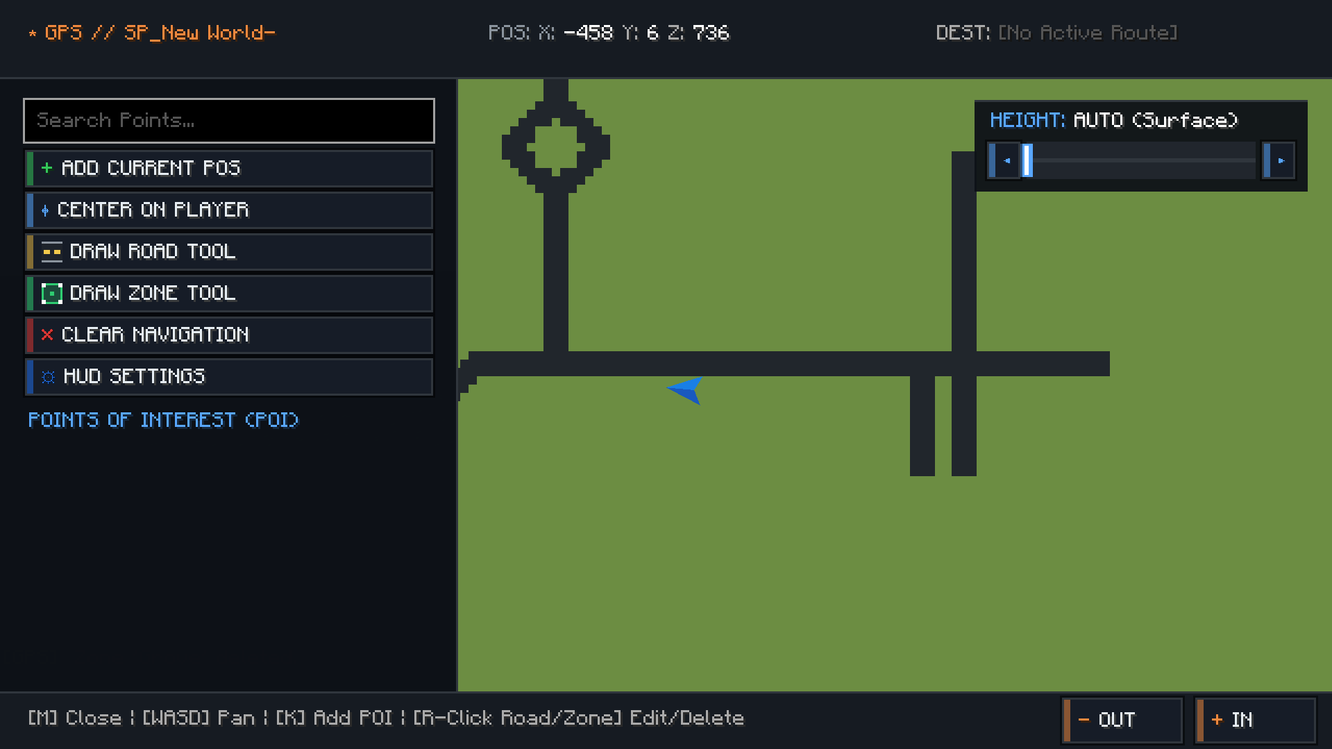 image-attachment_c5b06976-13ae-4adf-b587-bf31d8f7a1d3.png
 -
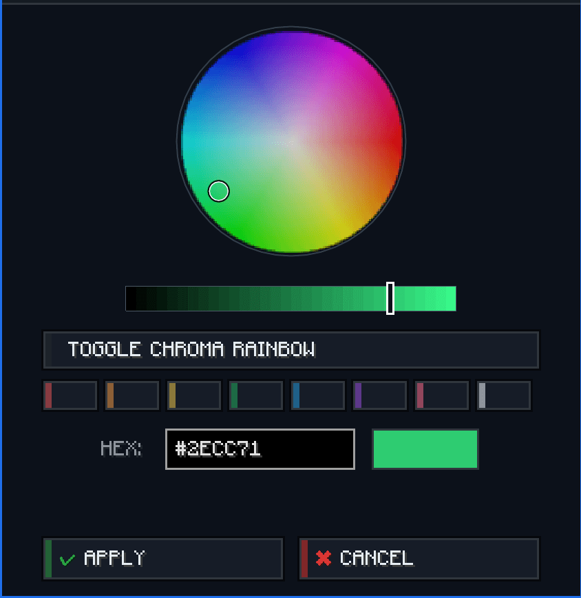 image-attachment_453ceaa1-041c-4288-9c43-fe420436a041.png
Versions
Files
Relations
Project Relations
More like this
Similar Mods
Suggestions use data such as tags, dependencies, dependents, descriptions, titles, and more to rank how much they overlap with this mod.
On ModDex
Community snapshot
By the numbers
Statistics
Want to reach Minecraft players?
We're looking for a server hosting partner to feature here and other parts of the site. Interested? Send us a message!
Get in touchGet it on
Available Platforms
On ModDex
Community snapshot
By the numbers
Statistics
Resources